
14.1. Site and Survey Metadata#
SiteMeta and LocationMeta describe one station – its
identity, geographic position, and acquisition interval – while
SurveyMeta and BBox describe the campaign that
collected it. Both are format-neutral metadata: the same
objects are produced whether the underlying file is a historical EDI
or an EMTF XML document, so a station’s project name, coordinates, or
survey affiliation is recorded once rather than being re-derived
separately for each format.
These are not the identity-editing tools covered in
Site Metadata. SiteMetadataEditor
rewrites EDI HEAD/INFO fields on a Site
or Sites collection and enforces its own
Station identity invariant across object, HEAD, and
SECTID. SiteMeta and SurveyMeta are one level below that:
plain, validated data objects that a format adapter reads from or
writes into a file, with no editing workflow, transaction, or audit
trail of their own. A single real EDI file will show below why this
distinction is not academic – the two layers can legitimately resolve
a station’s identity differently.
14.1.1. Location and Identity Fields#
LocationMeta holds latitude, longitude, elevation, datum,
elevation units, and optional magnetic declination. SiteMeta
wraps a LocationMeta together with project, survey, country,
site identifier, human-readable name, acquisition interval, and who
acquired it. Both validate eagerly in __post_init__, so an invalid
object cannot exist even transiently:
>>> from pycsamt.metadata import SiteMeta, LocationMeta

>>> loc = LocationMeta(latitude=32.1203, longitude=119.128833, elevation=99.0)
>>> print(loc)
LocationMeta(latitude=32.1203, longitude=119.128833, elevation=99.0, datum='WGS84', elevation_units='meters', declination=None, declination_epoch=None, extra=dict(len=0, keys=[]))

>>> site_meta = SiteMeta(
...     project="Copper-gold exploration",
...     survey="WILLY_L18",
...     year_collected=2023,
...     site_id="18-001A",
...     name="Chuzhou North",
...     location=loc,
...     acquired_by="EarthAI-Tech",
... )
>>> print(site_meta)
SiteMeta(project='Copper-gold exploration', survey='WILLY_L18', year_collected=2023, country=None, site_id='18-001A', name='Chuzhou North', location=LocationMeta(latitude=32.1203, longitude=119.128833, elevation=99.0, datum='WGS84', elevation_units='meters', declination=None, declination_epoch=None, extra=dict(len=0, keys=[])), acquired_by='EarthAI-Tech', ...)
>>> print(site_meta.preferred_name)
Chuzhou North
The trailing ... is PyCSAMTObject’s
generic __repr__ capping display at eight fields, not a sign that
start/end were dropped – both classes still carry every field
declared on the dataclass. preferred_name falls back
to site_id only when name is empty; had name been omitted
above, it would have returned "18-001A" instead.
Coordinate validation rejects a non-finite or out-of-range latitude or longitude at construction time rather than letting it reach a downstream projection or map:
where \(\phi\), \(\lambda\), and \(h\) are latitude, longitude, and elevation.
>>> try:
...     LocationMeta(latitude=91.0, longitude=0.0)
... except ValueError as exc:
...     print(type(exc).__name__, exc)
ValueError latitude must be finite and within [-90, 90]
Elevation, declination, and declination epoch are checked for finiteness only – (1) bounds latitude and longitude but leaves elevation unbounded, since a station can legitimately sit below sea level or on a high plateau.
14.1.2. Two Independent Identity Resolvers#
A real file from the repository’s WILLY L18 line shows how SiteMeta
and Site can disagree about a station’s
identity, and why that is by design rather than a bug.
>>> from pathlib import Path
>>> from pycsamt.seg.edi import EDIFile
>>> from pycsamt.site import Sites
>>> from pycsamt.site.base import Site
>>> from pycsamt.emtf import EMTF

>>> data_root = Path("data/AMT/WILLY_DATA")
>>> l18_paths = sorted((data_root / "L18PLT").glob("*.edi"))
>>> print(len(l18_paths))
28

>>> edi_bare = EDIFile(l18_paths[0])
>>> print(edi_bare.get_section("head").dataid)
23-18-001A
>>> tf_bare = EMTF.from_edi(edi_bare)
>>> print(tf_bare.site.site_id)
23-18-001A

>>> site = Site(EDIFile(l18_paths[0]))
>>> print(site.name)
18-001A
>>> print(site.site_meta.site_id)
18-001A
>>> print(site.site_meta is site.tf.site)
True
18-001A.edi genuinely stores HEAD.DATAID = "23-18-001A" on
disk. Converting the bare EDIFile with
EMTF.from_edi() preserves that value verbatim in
SiteMeta.site_id – the EMTF-XML design principle that a scientific
object must not fabricate or silently normalize identity applies here
too. Site, by contrast, documents that its constructor rewrites
HEAD.DATAID (and station, if absent) to the file stem so that
name-based lookup, ordering, and export stay consistent across a whole
Sites collection (see Station
identity); site.tf is then materialized from that already
renamed EDI object, so site.site_meta.site_id reports the
normalized stem instead of the raw DATAID. Both are correct for
what they are asked to do. The practical rule: build SiteMeta
straight from a bare EDI object when the on-disk identifiers must be
preserved as delivered (an audit or provenance record, for example),
and go through Site/Sites first when consistent lookup and
export naming matter more than reproducing the raw file bytes.
14.1.3. Campaign-Level Aggregation#
SurveyMeta describes the campaign rather than one station.
SurveyMeta.from_sites() derives it from a whole
Sites collection, computing a
BBox from every station’s coordinates and counting stations
along the way:
>>> from pycsamt.metadata import SurveyMeta, BBox

>>> sites = Sites([EDIFile(p) for p in l18_paths])
>>> print(len(sites))
28

>>> survey = SurveyMeta.from_sites(
...     sites,
...     name="WILLY_L18_2023",
...     method="amt",
...     project="Copper-gold exploration",
...     operator="EarthAI-Tech",
... )
>>> print(survey)
SurveyMeta(name='WILLY_L18_2023'  method=AMT  n=28)
>>> print(survey.bbox)
BBox(lat=[32.1203, 32.1420]  lon=[119.1285, 119.1290])
>>> print(survey.is_complete)
True
>>> print(survey.duration_days)
None
>>> print(survey.summary())
Survey: 'WILLY_L18_2023'  method=AMT
  Project : Copper-gold exploration
  Operator: EarthAI-Tech
  Area    : lat [32.12, 32.14]  lon [119.13, 119.13]  centre (32.131°N, 119.129°E)
  Stations: 28
method="amt" was upper-cased and validated against the fixed set
of known EM methods in __post_init__; an unrecognized method raises
immediately rather than silently storing free text.
duration_days is None because
from_sites() only derives station count and the
bounding box from the collection – it does not inspect each station’s
acquisition dates, so date_start/date_end stay unset unless
passed explicitly as keyword arguments.
is_complete only checks that name, method,
bbox, and n_stations are populated; it does not require dates,
so a campaign still mid-acquisition can already report True.
14.1.4. Bounding-Box Geometry#
BBox is a plain axis-aligned rectangle in decimal degrees. Its
convenience properties turn the four corner values into the quantities
a survey-design or map workflow actually needs:
>>> bbox = survey.bbox
>>> print(bbox.centre)
(32.131125, 119.12875)
>>> print(bbox.area_deg2)
1.1546666666742875e-05
>>> print(bbox.span_lat, bbox.span_lon)
0.021650000000001057 0.0005333333333368273
>>> print(sites[0].coords[:2] in bbox)
True
>>> print((0.0, 0.0) in bbox)
False
in and contains() are equivalent for a (lat, lon)
pair; __contains__ additionally accepts a bare number to test
latitude membership alone. The area, \(\approx 1.15\times10^{-5}\)
square degrees, is not a meaningful footprint here: L18 is a
north-south line, so span_lon is roughly forty times
smaller than span_lat and the “area” mostly reflects a
sliver, not a surveyed region. BBox still earns its keep on a line
survey – as the fast, exact containment test used above – but its
area_deg2 is only informative for area surveys with
comparable latitude and longitude extents.
The figure below reproduces this geometry directly, drawing every station, the bounding box computed above, and its centre:
import matplotlib.pyplot as plt
from matplotlib.patches import Rectangle

lats = [s.coords[0] for s in sites]
lons = [s.coords[1] for s in sites]

fig, ax = plt.subplots(figsize=(5, 6))
ax.scatter(lons, lats, s=28, c="#1f77b4", zorder=3, label="Stations")
rect = Rectangle(
    (bbox.lon_min, bbox.lat_min),
    bbox.span_lon,
    bbox.span_lat,
    fill=False,
    edgecolor="#d62728",
    linewidth=1.5,
    zorder=2,
    label="SurveyMeta.bbox",
)
ax.add_patch(rect)
centre_lat, centre_lon = bbox.centre
ax.scatter(
    [centre_lon], [centre_lat],
    marker="+", s=140, c="#d62728", zorder=4, label="bbox.centre",
)
ax.set_xlabel("Longitude (degrees)")
ax.set_ylabel("Latitude (degrees)")
ax.set_title("WILLY L18 survey bounding box (28 stations)")
ax.set_xlim(bbox.lon_min - 0.003, bbox.lon_max + 0.003)
ax.legend(loc="upper left", fontsize=9)
fig.tight_layout()
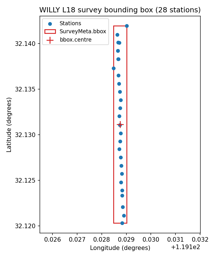
Every L18 station with the SurveyMeta.bbox rectangle and centre
overlaid. Two stations sit measurably west of the main line – real
line jogs, not a plotting artifact – which is exactly why the box
is wider than a perfectly straight line would need.#
14.1.5. Serialization and EDI Round-Trip#
Unlike SiteMeta/LocationMeta, which only expose the generic
to_dict() inherited from
PyCSAMTObject, SurveyMeta defines its own JSON and YAML
round-trip and can push its fields into an EDI HEAD section:
>>> from tempfile import TemporaryDirectory

>>> with TemporaryDirectory() as tmp:
...     json_path = Path(tmp) / "survey.json"
...     survey.to_json(json_path)
...     print(json_path.read_text()[:120] + " ...")
...     survey_reloaded = SurveyMeta.from_json(json_path)
...     print(survey_reloaded.bbox)
...     print(survey_reloaded.bbox == survey.bbox)
{
  "name": "WILLY_L18_2023",
  "project": "Copper-gold exploration",
  "operator": "EarthAI-Tech",
  "method": "AMT",
  ...
BBox(lat=[32.1203, 32.1420]  lon=[119.1285, 119.1290])
True

>>> print(survey.to_yaml())
bbox:
  lat_max: 32.14195
  lat_min: 32.1203
  lon_max: 119.12901666666666
  lon_min: 119.12848333333332
crs: WGS84
date_end: null
date_start: null
method: AMT
n_stations: 28
name: WILLY_L18_2023
notes: ''
operator: EarthAI-Tech
project: Copper-gold exploration

>>> head = sites[0].edi.get_section("head")
>>> print(head.project, head.acqby)
None None
>>> survey.update_edi_head(head)
>>> print(head.project, head.acqby)
Copper-gold exploration EarthAI-Tech
to_yaml() requires PyYAML, raising a clear
ImportError naming the missing dependency rather than failing
inside a generic serializer if it is absent.
update_edi_head() only writes project and
operator (mapped to acqby) today, and only when the
corresponding SurveyMeta field is not None – it will not
overwrite an existing HEAD value with a blank one, but it also will
not yet push bbox, method, or acquisition dates into EDI; those
remain JSON/YAML-only until a future EDI mapping is added.
14.1.6. SiteMeta Inside an EMTF Document#
A EMTF document holds site as one
of its format-neutral metadata slots (EMTF.site), alongside the
legacy station/lat/lon/elev fields kept for backward
compatibility with code written against the older
TFBundle model. When both are supplied, the
document enforces that they agree:
>>> from pycsamt.emtf import EMTF

>>> tf_ok = EMTF(site=site_meta)
>>> print(tf_ok.lat, tf_ok.lon)
32.1203 119.128833

>>> try:
...     EMTF(site=site_meta, lat=0.0)
... except ValueError as exc:
...     print(type(exc).__name__, exc)
ValueError legacy lat conflicts with SiteMeta: 0.0 != 32.1203

>>> tf_consistent = EMTF(site=site_meta, lat=32.1203)
>>> print(tf_consistent.lat)
32.1203
tf_ok leaves lat/lon unset explicitly, so
EMTF fills them from
site_meta.location automatically – this is how tf_bare.lat
was populated for free in the identity example above. Passing a
legacy lat that actually disagrees with SiteMeta raises rather
than silently picking one value, because the EMTF-XML design principle
that conversions must never silently discard or override scientifically
relevant content applies just as much to two representations of the
same document as it does to two different file formats. Passing the
same, consistent value is accepted – the check compares values, not
whether the field was supplied.
14.1.7. Choosing the Right Object#
Need |
Object |
Notes |
|---|---|---|
One station’s identity, position, and dates |
Coordinate-validated at construction; no EDI-editing workflow. |
|
Campaign-level bounding area and station count |
Build with |
|
Rewriting EDI |
See Site Metadata; enforces Station identity. |
|
A station’s metadata as part of a full transfer-function document |
|
Cross-checked against legacy |
14.1.8. Next Steps#
Provenance and Bibliography covers who created and processed a document and how to cite it;
Channels and Orientation covers the channel geometry that gives a transfer-function matrix’s axes physical meaning;
Site Metadata covers renaming, batch-editing, and exporting EDI
HEAD/INFOfields with a full audit trail.